Sentier des Corniches du Mejean (Le Rozier Capluc) Version courte

LIMOS
User
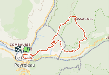

Length
10.7 km

Max alt
872 m

Uphill gradient
691 m
Km-Effort
19.9 km

Min alt
398 m

Downhill gradient
690 m
Boucle
Yes
Creation date :
2022-04-24 16:18:10.643
Updated on :
2022-06-06 16:02:02.859
6h08
Difficulty : Very difficult

FREE GPS app for hiking
 SityTrail
IGN / Geographical institutes
SityTrail Plus
The world is yours!
About
Trail Walking of 10.7 km to be discovered at Occitania, Lozère, Le Rozier. This trail is proposed by LIMOS.
Positioning
Country:
France
Region :
Occitania
Department/Province :
Lozère
Municipality :
Le Rozier
Location:
Unknown
Start:(Dec)
Start:(UTM)
516530 ; 4893179 (31T) N.
Comments